

Satellite Image Time Series Analysis for Big Earth Observation Data
by Rolf Simoes 1 , Gilberto Camara 1, Gilberto Queiroz 1, Felipe Souza 1, Pedro R. Andrade 1, Lorena Santos 1, Alexandre Carvalho 2 and Karine Ferreira 1
1National Institute for Space Research (INPE), Avenida dos Astronautas, 1758, Jardim da Granja, Sao Jose dos Campos, SP 12227-010, Brazil
2National Institute for Applied Economics Research, SBS, Quadra 1 Bloco J, Brasília, DF 70076-900, Brazil
Remote Sens. 2021, 13(13), 2428; https://doi.org/10.3390/rs13132428
Publisher: mdpi | Published: 22 June 2021
(This article belongs to the Special Issue Big Earth Observation Data: From Cloud Technologies to Insights and Foresight)
Abstract
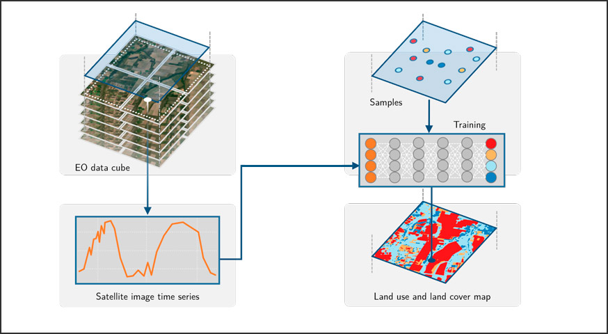
The development of analytical software for big Earth observation data faces several challenges. Designers need to balance between conflicting factors. Solutions that are efficient for specific hardware architectures can not be used in other environments. Packages that work on generic hardware and open standards will not have the same performance as dedicated solutions. Software that assumes that its users are computer programmers are flexible but may be difficult to learn for a wide audience. This paper describes sits, an open-source R package for satellite image time series analysis using machine learning. To allow experts to use satellite imagery to the fullest extent, sits adopts a time-first, space-later approach. It supports the complete cycle of data analysis for land classification. Its API provides a simple but powerful set of functions. The software works in different cloud computing environments. Satellite image time series are input to machine learning classifiers, and the results are post-processed using spatial smoothing. Since machine learning methods need accurate training data, sits includes methods for quality assessment of training samples. The software also provides methods for validation and accuracy measurement. The package thus comprises a production environment for big EO data analysis. We show that this approach produces high accuracy for land use and land cover maps through a case study in the Cerrado biome, one of the world’s fast moving agricultural frontiers for the year 2018. View Full-Text
Keywords: big Earth observation data; data cubes; satellite image time series; machine learning and deep learning for remote sensing; R package
© This is an open access article distributed under the Creative Commons Attribution License which permits unrestricted use, distribution, and reproduction in any medium, provided the original work is properly cited