
Web Service for extracting Phenological Metrics for Agriculture using time series of satellite images
by Gabriel Kyama Alves¹, Karine R. Ferreira¹, Bruno Schultz, Thiago G. Rodrigues e Luiz F.R. Carvalho
1National Institute for Space Research (INPE), Brazil
GeoInfo: http://mtc-m21d.sid.inpe.br/rep/8JMKD3MGP3W34T/488BPNL
Publisher: GeoInfo | Published: 29 November 2022
© Author(s) 2022. This work is distributed under the Creative Commons Attribution 4.0 License.
Abstract
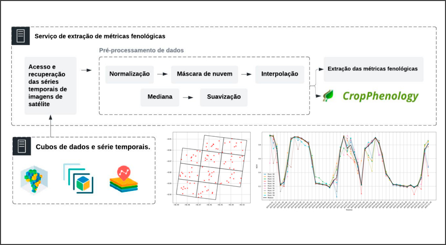
The study of seasonal vegetation patterns observed by remote sensing is called Land Surface Phenology (LSP). From remote sensing images, it is possible to obtain metrics used for phenological monitoring that help in understanding the dynamics of vegetation and in decision making. There are different methods in the literature for extracting these metrics from satellite images. However, one of the challenges is extracting these metrics from the large volumes of images currently available from different providers. Specialists are faced with hardware limitations to process this large volume of data on personal computers. For this, the objective of this work is to develop a web service for extracting phenological metrics from large volumes of images modeled as multidimensional data cubes and time series of vegetation indices. This service follows a “client-server” architecture, processing all data on the server side and returning only the processing result to the client. Using this service, an expert can extract metrics from large volumes of images without worrying about processing limitations and with installations of packages and systems on your personal computer.
Keywords: web service; phenological metrics; EO data cubes; time series
Share and Cite
Alves, G.K; Ferreira, K.R; Schultz, B.; Rodrigues, T.G.; Carvalho, L.F.R. Web Service for extracting Phenological Metrics for Agriculture using time series of satellite images. In: Brazilian Symposium on Geoinformatics (GEOINFO-2022), 281-286. Proceedings XXIII GEOINFO, November 28 to 30, 2022. São José dos Campos, SP, Brazil. INPE, 2022. ISSN 2179-4847. http://mtc-m21d.sid.inpe.br/rep/8JMKD3MGP3W34T/488BPNL