
TerraCollect is a web tool for Brazil Data Cube sample collection and analysis. It offers vector drawing and high-resolution multi-temporal image visualization capabilities, encompassing various image collections within the BDC ecosystem.
Through a web application, TerraCollect allows you to create data collection projects in a multi-user environment. Each project allows for the specification of image collections sourced from the Brazil Data Cube catalog to be defined. TerraCollect offers a set of tools to support experts throughout the sampling process: Integration with the Brazil Data Cube sample database, Sample-DB; Visualization of cubes and image collections, with timeline and RGB composition editing; Facilitates the examination of time series and land use and cover trajectory through the Time Series Services (WTSS) and Web Land Trajectory Service (WLTS) graphs components; Additionally, the tool facilitates the integration of external mapping resources such as PRODES, TerraClass, and MapBiomas to augment analysis endeavors.
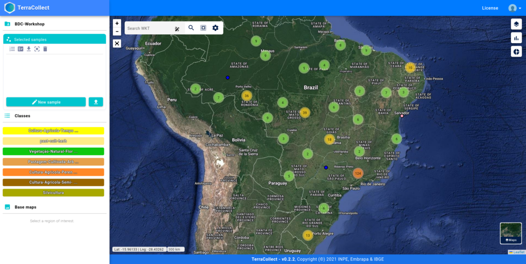
TerraCollect main screen
Within TerraCollect, experts can collect samples of land use and cover based on the analysis of time series data extracted from images and the interpretation of high-resolution satellite imagery provided by the Brazil Data Cube Project. For each project, a set of land use and cover data is also defined, the classification system used to label points (samples) and their respective symbols.
Presently operating on version 1.0.0, this system implements a user access control mechanisms facilitated by an authentication system developed by the Brazil Data Cube team.
TerraCollect Features

Visualize big data sets of satellite images over time.

Visualize land use and land cover maps.

Extract image time series for informed spatial locations.

Access land use and land cover trajectories for informed spatial locations.

Create and edit classification systems and land use and land cover samples.

Analyze the balance of samples by land use and land cover type.

Analyze the image time series pattern by land use and land cover type.

Analyze the land use and land cover samples using class noise reduction and machine learning methods.

Store the collected land use and land cover samples in a cloud.

Public the collected land use and land cover sample for all users.

Brazil Data Cube project reference paper
by Karine R. Ferreira,Gilberto R. Queiroz,Lubia Vinhas,Rennan F. B. Marujo,Rolf E. O. Simoes,Michelle C. A. Picoli,Gilberto Camara,Ricardo Cartaxo,Vitor C. F. Gomes,Lorena A. Santos,Alber H. Sanchez,Jeferson S. Arcanjo,José Guilherme Fronza,Carlos Alberto Noronha,Raphael W. Costa,Matheus C. Zaglia,Fabiana Zioti,Thales S. Korting,Anderson R. Soares,Michel E. D. Chaves andLeila M. G. Fonseca Earth Observation and Geoinformatics Division, National Institute for Space Research …