
TerraClass Cerrado launches mapping produced with technologies and data from the Brazil Data Cube project.
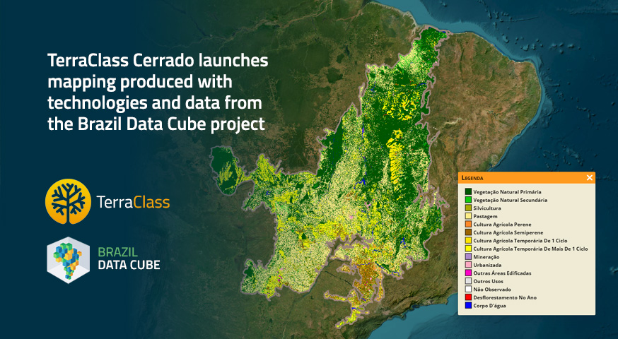
The TerraClass Cerrado project released on December 15, 2022, a mapping of land use and land cover in the biome for the year 2020, produced using technologies and data from the Brazil Data Cube project. This mapping was generated using time series analysis extracted from large volumes of Sentinel-2 satellite imagery data cubes and artificial intelligence, and it is available on the TerraClass GeoPortal.
TerraClass Cerrado is a partnership between the Ministry of Agriculture, Livestock and Food Supply (MAPA), the Brazilian Agricultural Research Corporation (Embrapa), and the National Institute for Space Research (INPE), under the Ministry of Science, Technology, and Innovation (MCTI).
Brazil Data Cube (BDC) is an INPE project that is generating analysis ready data and multidimensional data cubes for the entire country and developing a national platform with innovative technologies to extract land use and land cover information from these large volumes of data using time series analysis and artificial intelligence. The project is creating and freely providing technological innovation within the scope of the Amazon and other Biomes Monitoring Program and its associated projects, such as TerraClass.
To produce the mapping, the TerraClass Cerrado project team accessed and processed the virtual data cubes of high spatial resolution imagery for the entire Cerrado biome, available on the Brazil Data Cube platform running on INPE’s computational infrastructure.
Using this platform, its services, and systems, the team processed a large volume of images on INPE servers without the need to download them to their personal machines, resulting in greater efficiency in the mapping process with reduced time and production costs.
Currently, the Brazil Data Cube platform is running on the computational infrastructure of the Earth Observation and Geoinformatics Division (DIOTG) at INPE, and it is in the process of migrating to the new Data Infrastructure and Supercomputing Coordination (COIDS).
The main services and systems of the Brazil Data Cube platform used in the mapping process were: (1) SITS: an R programming language package for time series analysis of satellite imagery and land use and land cover classification; (2) Web Time Series Service (WTSS): a web service for extracting time series from collections and data cubes of remote sensing imagery; and (3) Web Land Trajectory Service (WLTS): a web service for integrating, harmonizing, and extracting land use and land cover trajectories from classified maps.
Source: TerraClass Cerrado and Brazil Data Cube project teams.