
Integracão dos ambientes Brazil Data Cube e Open Data Cube
by Felipe Menino Carlos¹, Vitor C. F. Gomes², Gilberto Ribeiro de Queiroz¹,
Karine Reis Ferreira¹, Rafael Santos¹
¹Instituto Nacional de Pesquisas Espaciais (INPE) – 12227-010 – Sao José dos Campos – SP – Brasil
² Divisao de C4ISR – IEAV/DCTA – 12.228-001 – Sao José dos Campos – SP – Brasil
Publisher: Anais do 21º GEOINFO | Published: 3 December 2020
Abstract
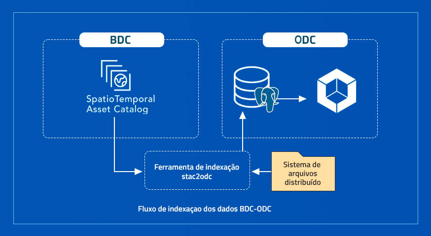
The availability of large quantities of Earth observation data by satellite images has enabled different technologies and research. Given the challenges that this volume of data resents, the organization of these in data cube formats becomes fundamental for any large scale study. Providing tools that use these data cubes simpler allows their widespread use in various contexts. This article aims to present the ongoing work on the extension of the data cube analysis and visualization tools produced by the Brazil Data Cube project by integrating these tools with the Open Data Cube framework.
Keywords:
© This is an open access article distributed under the Creative Commons Attribution License which permits unrestricted use, distribution, and reproduction in any medium, provided the original work is properly cited